Maps make me feel more at home. I like Bibles with maps; I like text books with maps; I like novels with maps. Maps help me to know where a character, or a story, is headed – whether it is Paul on his missionary journeys or the hero of a novel. However, making maps can take a lot of planning. With the series Terror on Every Side! it was hard to include all the places of interest when some are only a hundred metres apart while others are scattered over thousands of kilometres. Now, finally, I can present some “Jeremiah maps”.
First there is a list of places of interest in the story of the life of Jeremiah, and they are grouped in categories from the smallest area (Jerusalem) to the largest area (the Middle East). Three maps covering the same areas are included below.
The largest list of places in the book of Jeremiah is given in Jeremiah 25 when God is commanding him to take the cup of God’s wrath to the kings and leaders of many nations (see “God’s cup of anger”).
It is amazing to me just how many places are referred to in the book of Jeremiah, so much so that I have limited this list almost exclusively to places found in the book of Jeremiah, ignoring books like 2 Kings, 2 Chronicles, Ezekiel, Daniel, Habakkuk and Zephaniah that describe the same time and name some other places.
Jerusalem
- Zion (mostly appears almost interchangeable with Jerusalem) (17 times: eg. Jeremiah 50:5, 28; 51:10, 24,35)
- The temple (11 times) / the Lord’s house (9 times: eg. Jeremiah 7:2; 19:14; 26:2; 36:6) / house of the Lord (23 times: eg. Jeremiah 20:2; 26:10; 36:10):
- court (Jeremiah 19:14; 26:2)
- upper court (Jeremiah 36:10)
- both courts (2 Kings 21:5; 2 Chronicles 33:5)
- Entry of New Gate (Jeremiah 26:10; 36:10)
- 3rd entrance to/from (entrance from palace to temple?) (Jeremiah 38:14)
- Upper Benjamin Gate (Jeremiah 20:2)
- Chamber of sons of Hanan, the son of Igdaliah (Jeremiah 35:4)
- Chamber of officials (Jeremiah 35:4)
- Chamber of Maaseiah the son of Shallum (doorkeeper) (Jeremiah 35:4)
- Chamber of Gemariah, the son of Shaphan (scribe) (Jeremiah 36:10)
- Chamber of Nathan-melech (chamberlain) at the entrance of the temple (2 Kings 23:11)
- Houses of the male cult prostitutes (2 Kings 23:7)
- King’s palace(s) (Jeremiah 6:5; 9:21; 17:27; 30:18; 32:2):
- Court of the guard (located in the palace, Jeremiah 32:2) (Jeremiah 32:8, 12; 33:1; 37:21; 38:13, 28; 39:14-15)
- Cistern of Malchiah, the king’s son (Jeremiah 38:6-13) (located in the court of the guard, Jeremiah 38:6)
- Scribe’s (the secretary’s) chamber in palace (Jeremiah 36:12)
- Winter house in court of the king in the palace (Jeremiah 36:20-22)
- Chamber of Elishama the scribe (Jeremiah 36:20-21 – located in the palace (Jeremiah 36:12))
- King’s garden (against wall with a gate leading into the area between the walls) (Jeremiah 39:4; 52:7). Probably the same as the Garden of Uzza where King Manasseh and King Amon were buried (2 Kings 21:18, 26).
- Tower of Hananel (Jeremiah 31:38)
- Benjamin Gate (Jeremiah 37:12-13; 38:7)
- Corner Gate (Jeremiah 31:38)
- Horse Gate (Jeremiah 31:40)
- Middle Gate or middle of the gate (Jeremiah 39:3)
- People’s Gate? (Jeremiah 17:19)
- Potsherd Gate (Jeremiah 19:2)
- 2nd Quarter (home of Huldah) (2 Kings 22:14; 2 Chronicles 34:22; Zephaniah 1:10)
- Bakers’ street (Jeremiah 37:21)
- House of Jonathan the secretary/scribe (prison/dungeon) (Jeremiah 37:15-16, 20; 38:26)
- Valley of Ben Hinnom (Slaughter) / Topheth (Jeremiah 7:31-32; 19:2, 6; 32:35)
- Valley of the dead bodies (cemetery) (Jeremiah 31:40; 26:23? 2 Kings 23:6; 2 Chronicles 34:4)
- Brook Kidron (Jeremiah 31:40)
- Line to Hill Gareb and turn to Goah (Jeremiah 31:39)
Several of Jerusalem’s gates are mentioned in Jeremiah – see article “The city gates of Jerusalem”.
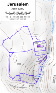
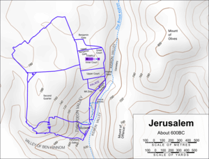
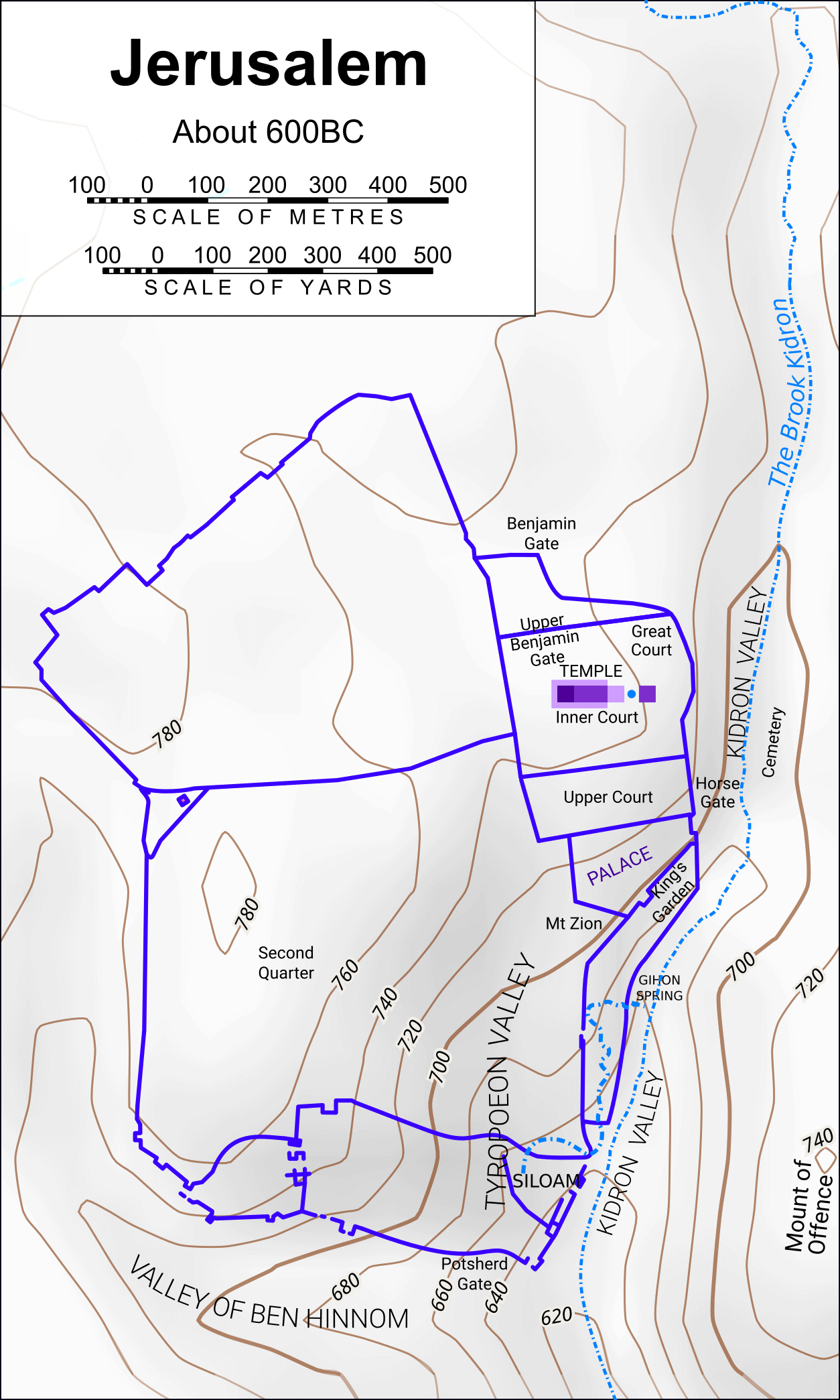
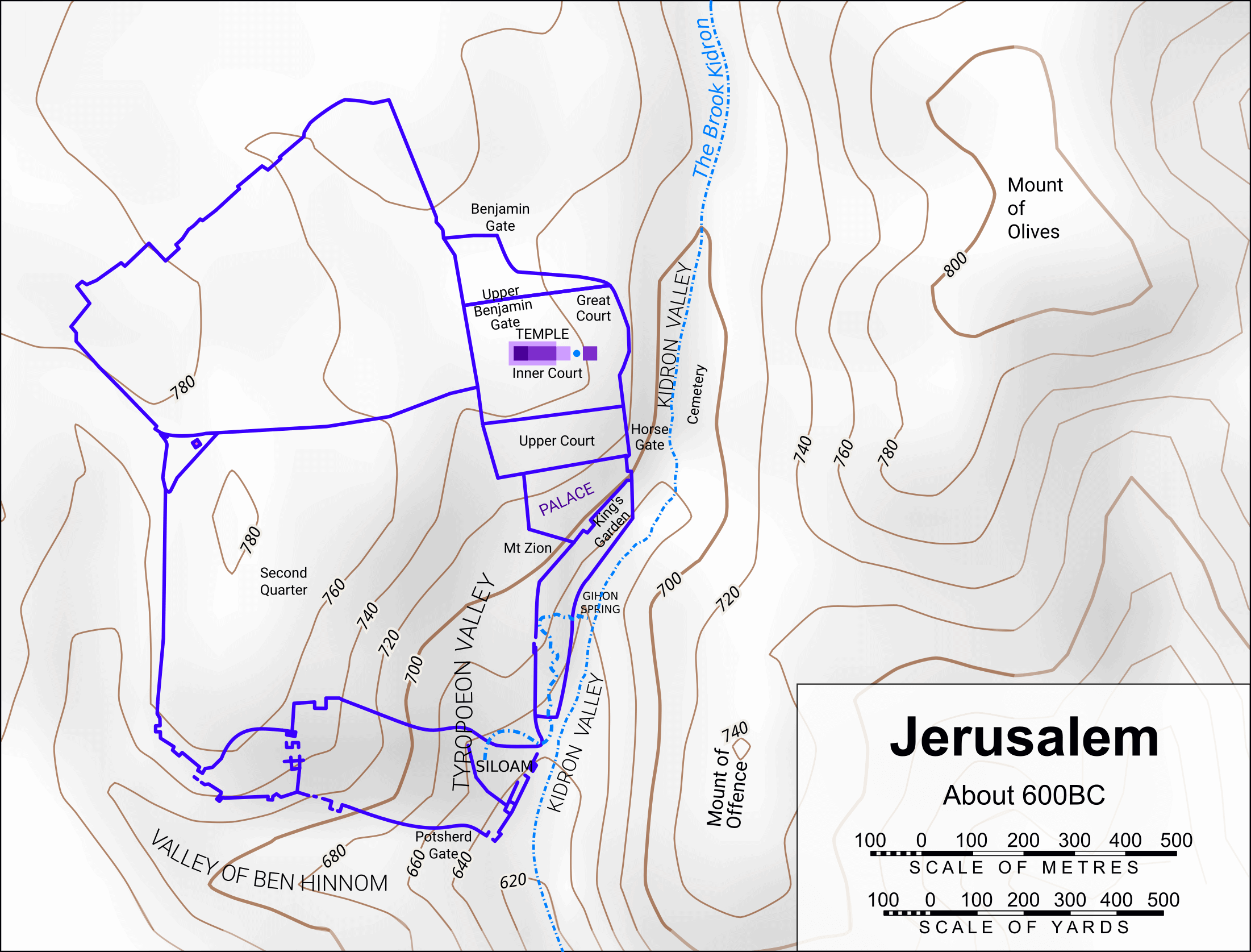
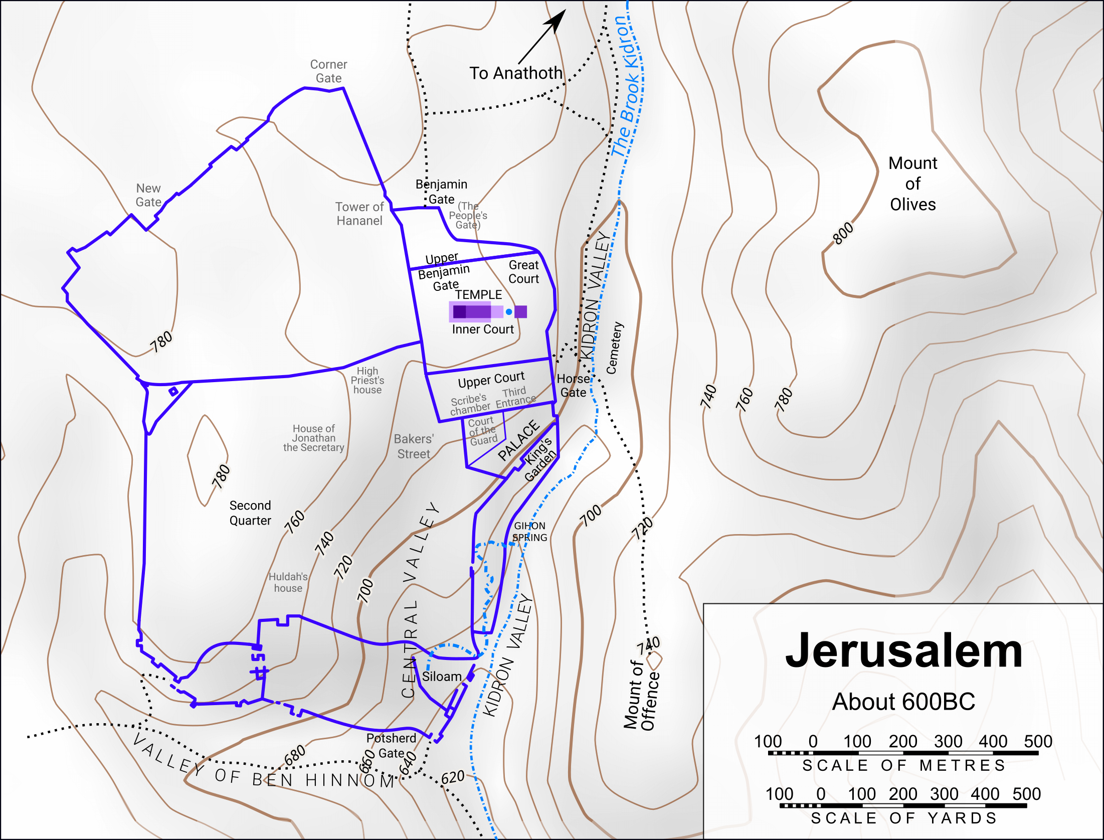
Maps of Jerusalem
Some of the places listed above are shown on the maps below: one in portrait mode and the other in landscape (last updated in April 2020). Click on each picture to see the map at a higher resolution.
Portrait mode
Landscape mode
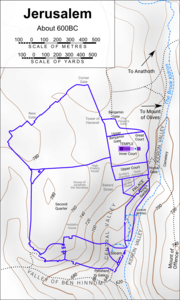
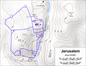
Jeremiah Maps: Jerusalem for Terror on Every Side!
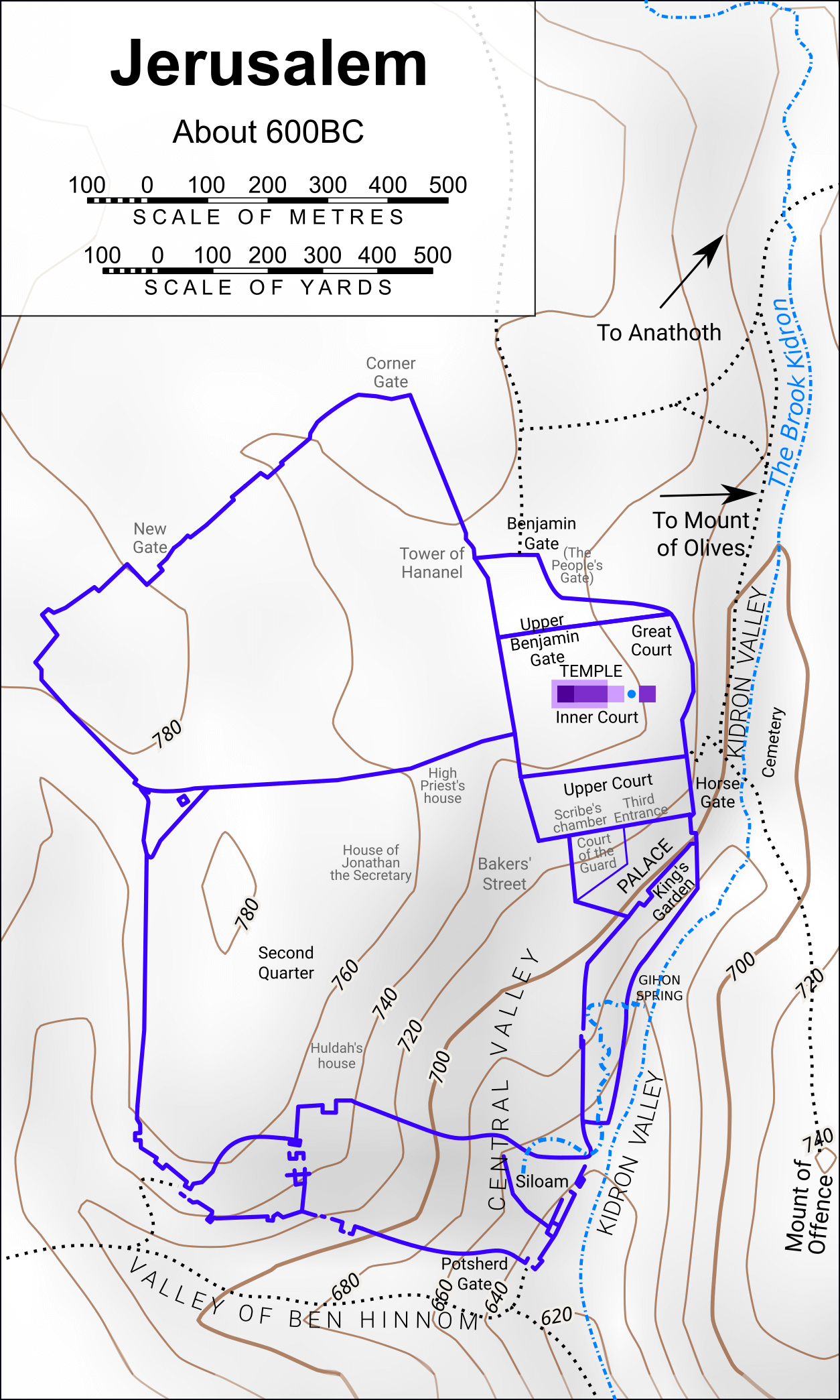
The series Terror on Every Side! on the life of Jeremiah has many events that take place in Jerusalem, so I have also created a version of the map of Jerusalem that identifies some of these places. These locations are marked in grey, since I have to admit that they are mostly guesswork.
Roads have also been added based on my guesses of the roads and gates that are important in the story.
Portrait mode
Landscape mode
Licensing for maps of Jerusalem
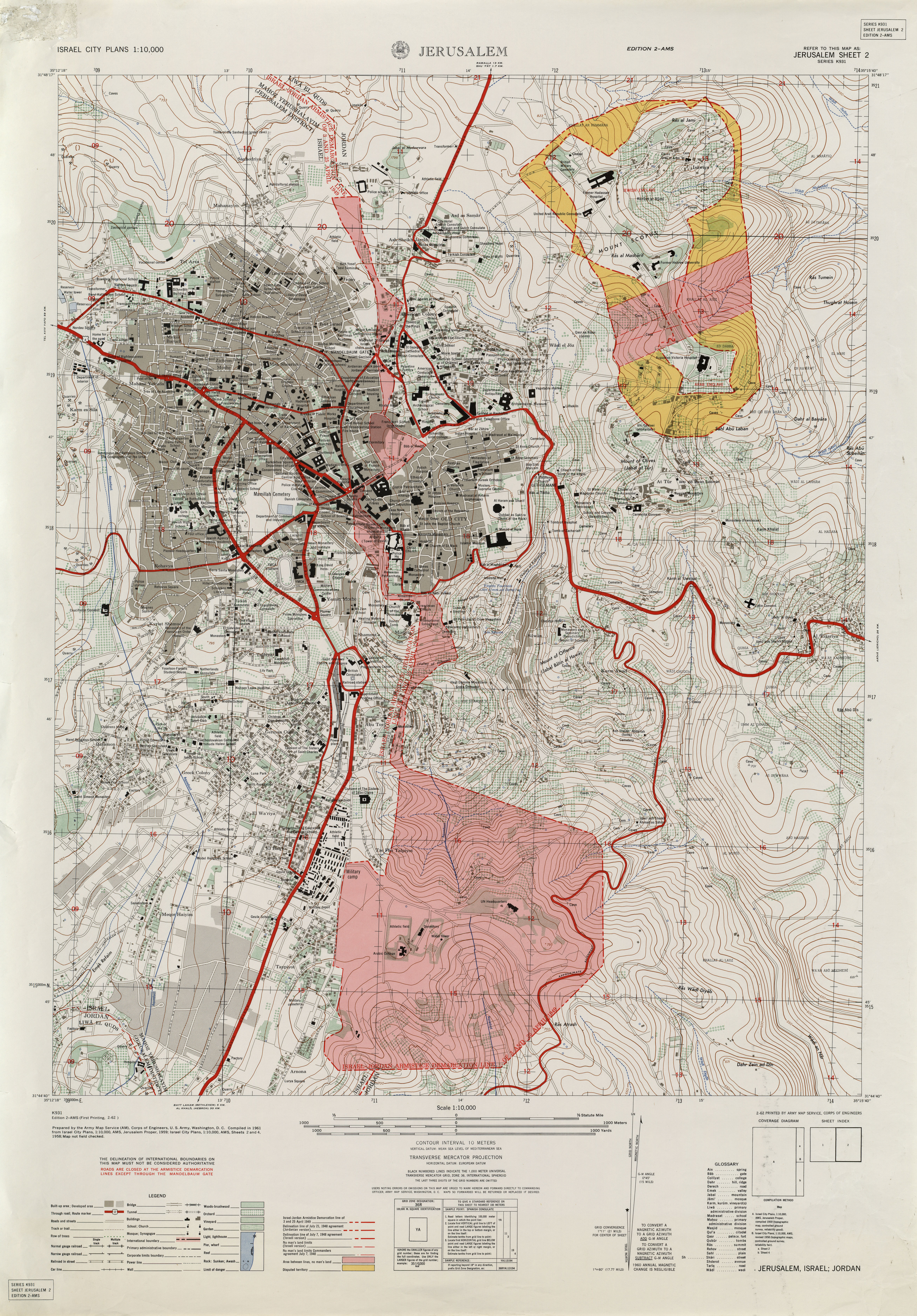
These maps have been built on a basic SVG map of Jerusalem which is available in the public domain (https://commons.wikimedia.org/wiki/File:C%2BB-Jerusalem-Map2-WallsAndContours.svg) and edited based on a large number of other sources. The contours were using NASA data through Maperative. In the SVG version, I have included OpenStreetMap layers which are © OpenStreetMap contributors, a note which must be included if those layers are ever displayed. Other sources include Army Map Service 1961, Series K931, Sheet Jerusalem 2, Edition 2-AMS (https://legacy.lib.utexas.edu/maps/world_cities/txu-oclc-36445576-jerusalem-1961.jpg) which is also included in a layer in the SVG file. At some time, I may make the SVG file available on the website, but it is large and needs tidying up first!
With the layers included in the maps above, I can make them available in the public domain. If you would like to have them in different resolutions, feel free to ask.
Judah/Israel
- Abarim (the mountains of) (Jeremiah 22:20) – region
- Anathoth (Jeremiah 1:1; 11:21, 23; 29:27; 32:7-9) – town
- Arabah (dry and desolate area) (Jeremiah 39:4; 52:7) – region
- Azekah (Jeremiah 34:7) – town
- Bashan (Jeremiah 22:20; 50:19) – region
- Bethel (Jeremiah 48:13) – city
- Beth-haccherem (Jeremiah 6:1) – town
- Bethlehem (Jeremiah 41:17) – town
- Mount Carmel (Jeremiah 46:18; 50:19) – mountain and region
- Dan (Jeremiah 4:15; 8:16) – town
- Hill country of Ephraim (Jeremiah 31:6; 50:19) – region
- Mount Ephraim (Jeremiah 4:15) – probably the same as the Hill country of Ephraim above
- Geruth Chimham (Jeremiah 41:17) – possibly “Inn of Chimham”
- Gibeon (Jeremiah 41:16: Hananiah’s birthplace (Jeremiah 28:1); great pool (Jeremiah 41:12)) – city
- Gilead (Jeremiah 8:22; 22:6; 46:11; 50:19) – region
- Plains of Jericho (Jeremiah 39:5; 52:8) – region
- Jordan (thicket/jungle of, Jeremiah 12:5; 49:19; 50:44) – river and flood plain
- Kiriath-jearim (Uriah of, Jeremiah 26:20) – town
- Lachish (Jeremiah 34:7) – city
- Libnah (home town of King Zedekiah’s mother’s father, Jeremiah 52:1) – city
- Megiddo (2 Kings 23:29-30) – city
- Plain of Megiddo (2 Chronicles 35:22) – region
- Mizpah (Jeremiah 40:6, 8, 10, 12-13, 15; 41:1, 3, 6, 10, 14, 16) – city
- Moresheth (Micah of, Jeremiah 26:18) – town
- Negeb (the south) (Jeremiah 13:19; 17:26; 32:44; 33:13) – region
- Ramah (Jeremiah 31:15; 40:1) – city
- Samaria (Jeremiah 23:13; 31:5; 41:5) – city
- Shechem (Jeremiah 41:5) – town
- Shephelah (the lowlands) (Jeremiah 17:26; 32:44; 33:13) – region
- Shiloh (Jeremiah 7:12, 14; 26:6, 9; 41:5) – town (or ruin)
- Sodom and Gomorrah (gone!) (Jeremiah 23:14; 49:18; 50:40) – location unknown
- Mount Tabor (Jeremiah 46:18) – mountain
Jeremiah Maps: the kingdom of Judah and its neighbours
All of the places listed above (except for Sodom and Gomorrah) and many of the towns in surrounding countries are shown on the map below. This map was based on a high quality public domain SVG map of Israel and its borders from 1949 to 1967.
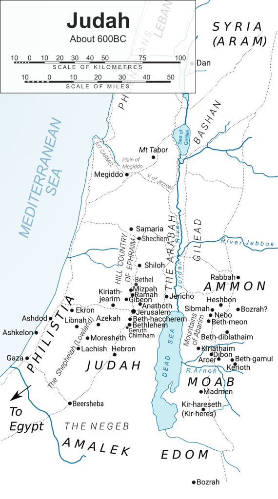
Note that this map is also available in SVG and in a variety of higher resolutions in PNG format. If you would like to have any of these, please let me know by emailing me. Other colour options that include altitude information are also available. This map in all its forms is released into the public domain.
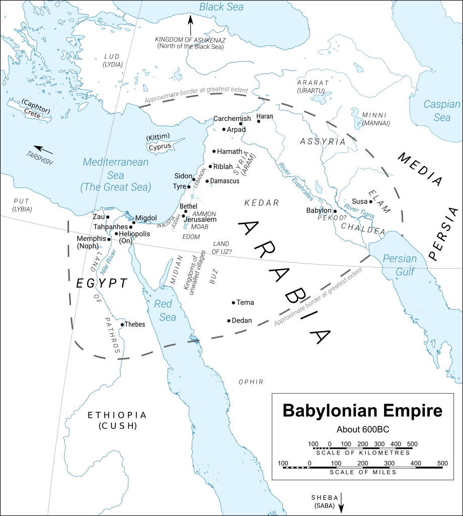
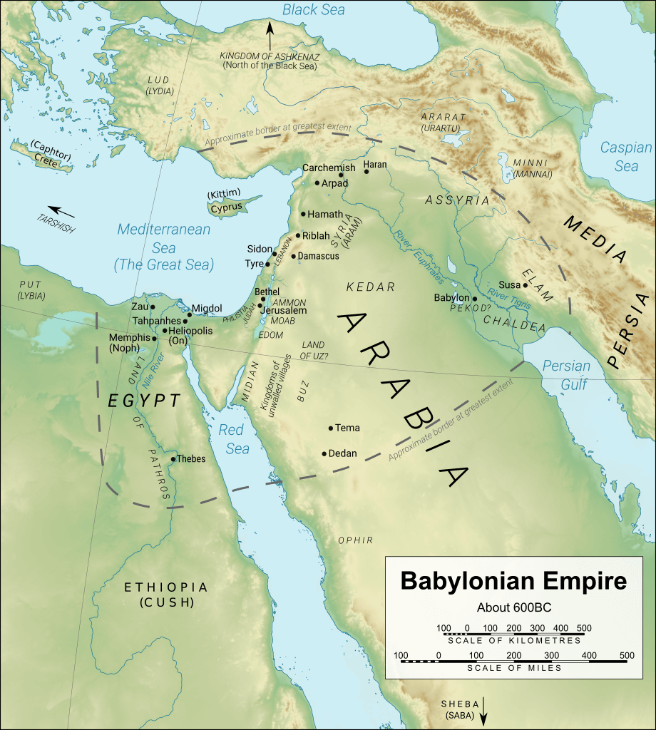
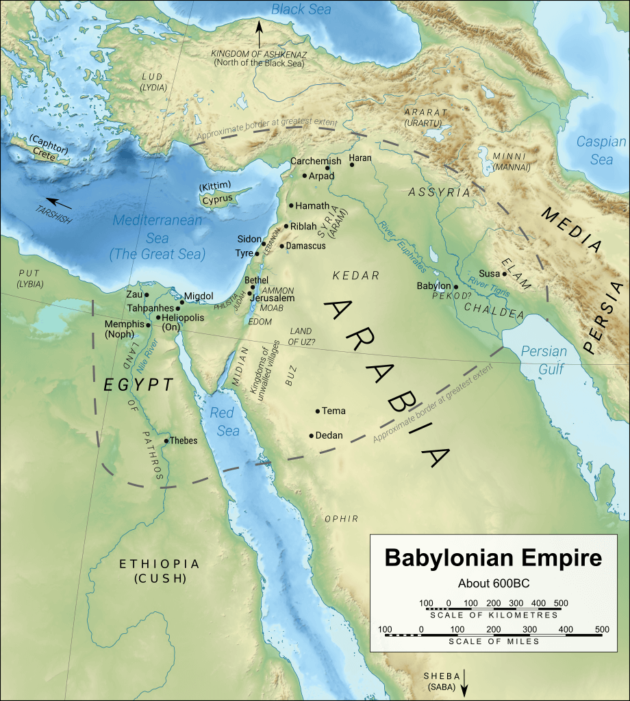
The Middle East
- Ammon – country:
- Rabbah (Jeremiah 49:2, 3) – city
- Heshbon (Jeremiah 48:2, 34, 45; 49:3) – town
- Ai? (Jeremiah 49:3) (Some suggest this is a scribal error. Location unknown.)
- Arabia (Jeremiah 25:24) probably closely related to “the desert” and the home of those who “cut the corners of their hair” (Jeremiah 9:26; 25:23) – region
- Kingdom of Ararat (Jeremiah 51:27) also known as Urartu
- Kingdom of Ashkenaz (Jeremiah 51:27)
- Assyria (Jeremiah 2:18, 36; 50:17-18) – country/region
- Babylon (Jeremiah 21:4; 27:16, 22; 29:1, 4, 10, 15, 20, 22, etc.) 171 references (88 times to the “king of Babylon”) Called Sheshak in some translations of Jeremiah 51:41, and probably synonymous with the land of Merathaim (or “double rebellion”) in Jeremiah 50:21) – city/region:
- Pekod (Jeremiah 50:21) – region south of Babylon?
- Euphrates River (Jeremiah 51:61-63)
- walls (Jeremiah 50:15; 51:12, 44), broad wall (Jeremiah 51:58)
- Buz (Jeremiah 25:23) – region
- Carchemish (by River Euphrates, Jeremiah 46:2) – city
- Chaldea (Jeremiah 21:4; 50:10; 51:24, 35) (Leb-kamai, Jeremiah 51:1) also 44 passages as “Chaldeans” – region south of Babylon which took over Babylon
- Coastlands of Caphtor (Crete) as origin of Philistines (Jeremiah 47:4) – island
- Cyprus / Kittim (Jeremiah 2:10) (Cyprus) – island
- Dedan (Jeremiah 25:23; 49:8) – city
- Edom (Jeremiah 9:26; 25:21; 27:3; 40:11; 49:7, 17, 20, 22) – country:
- Teman (Jeremiah 49:7, 20) – city
- Bozrah in Edom (Jeremiah 49:13, 22) – city
- Egypt (eg. Jeremiah 42:14-19: total 62 references) – country:
- River Nile (Jeremiah 2:18; 46:7-8)
- Tahpanhes (Jeremiah 2:16; 43:7-9; 44:1; 46:14) – city
- Pharaoh’s palace in Tahpanhes (Jeremiah 43:9)
- Memphis (Noph) (Jeremiah 2:16; 44:1; 46:14, 19) – city
- Migdol (Jeremiah 44:1; 46:14) – city
- Land of Pathros (Jeremiah 44:1, 15) – region
- Heliopolis (On) (obelisks, Jeremiah 43:13) – city
- Thebes, Amon, a god of (Jeremiah 46:25)
- Elam (Jeremiah 25:25; 49:34-39) – country
- Ethiopia / Cush (Jeremiah 13:23; 38:7, 10, 12; 39:16; 46:9) – country
- Euphrates River: hiding loincloth (Jeremiah 13:4-7); near Carchemish (Jeremiah 46:2, 6, 10); Assyria (Jeremiah 2:18); in Babylon (Jeremiah 51:61-63)
- Kingdoms of Hazor – may mean kingdoms of unwalled villages and mean tribes of desert dwellers living in the area near Kedar (Jeremiah 49:28, 30, 33) – region/nations (exact location unknown)
- Kedar (Jeremiah 2:10; 49:28) – country/region
- Lebanon (Jeremiah 18:14; 22:6, 20, 23) – country and region
- Mount Sirion (Jeremiah 18:14) (also known as Mount Hermon or Mount Senir – Deuteronomy 3:9; 4:48) – mountain/region
- Lud (Lydia) (Jeremiah 46:9) – region
- Media (Medes) (Jeremiah 25:25; 51:11, 28) – country
- Kingdom of Minni (Jeremiah 51:27) (also known as Mannai)
- Moab (Jeremiah 48:9) – country:
- Madmen (Jeremiah 48:2) – town
- Nebo (Jeremiah 48:1, 22) – town
- Kiriathaim (Jeremiah 48:1, 23) – town
- Horonaim (Jeremiah 48:3, 34; descent of – Jeremiah 48:5) (location unknown)
- Ascent of Luhith (Jeremiah 48:5) (location unknown)
- Dibon (Jeremiah 48:18, 22) – town
- Aroer (Jeremiah 48:19) – town
- Arnon River (Jeremiah 48:20)
- Holon (Jeremiah 48:21) (location unknown) – town
- Jahzah (Jeremiah 48:21) (location unknown) – town
- Mephaath (Jeremiah 48:21) (location unknown) – town
- Beth-diblathaim (Jeremiah 48:22) – town
- Beth-gamul (Jeremiah 48:23) – town
- Beth-meon (Jeremiah 48:23) – town
- Kerioth (Jeremiah 48:24; also 48:41 in NASB (“cities” in RSV/ESV))
- Bozrah in Moab (Jeremiah 48:24) – town (not to be confused with Bozrah in Edom)
- Kir-hareseth/Kir-heres (Jeremiah 48:31, 36) – town
- Jazer, Sea of Jazer (Jeremiah 48:32)
- Sibmah (Jeremiah 48:32) – town
- Sihon (Jeremiah 48:45) (location unknown) – town
- Philistia (Jeremiah 25:20; 47:1, 4) – region:
- Gaza (Jeremiah 25:20; 47:1, 5) – city
- Ashkelon (Jeremiah 25:20; 47:5, 7) – city
- Ekron (Jeremiah 25:20) – city
- Ashdod (Jeremiah 25:20) – city
- Put (Libya) (Jeremiah 46:9) – country
- Red Sea (Jeremiah 49:21) – sea
- Sheba (Jeremiah 6:20) – country
- Sidon (Jeremiah 25:22; 27:3; 47:4) – city
- Syria (Aram) – country:
- Damascus (Jeremiah 49:23-24, 27) – city
- Hamath (Jeremiah 39:5; 49:23; 52:9, 27) – city
- Riblah in the land of Hamath (Jeremiah 39:5; 52:9-10, 26-27) – city
- Arpad (Jeremiah 49:23) – city
- Tema (Jeremiah 25:23) – city
- Tyre (Jeremiah 25:22; 27:3; 47:4) – city
- Tarshish (Jeremiah 10:9) – country synonymous with trading
- Uphaz (Jeremiah 10:9) – possibly Ophir or maybe a region in India
- Land of Uz (Jeremiah 25:20) – region near Edom
- Zimri (Jeremiah 25:25) – (location unknown, although some suggest it is another name for Susa/Sushan in Elam)
Jeremiah Maps: the Babylonian Empire
Many of the counties, regions and cities listed above are shown on the maps below which were derived from a map by Yiyi of the Middle East with a CC BY 3.0 licence. This “derivative work” is released under the same licence. Click on each picture to see the map at a higher resolution.
Note that these maps are also available in SVG and in a variety of higher resolutions in PNG format. If you would like to have any of these, please let me know by emailing me.
See also
On other sites…
Subscribe to our newsletter
Enjoyed this article? Articles on this site summarise the research we do in writing our Bible-based fiction. If you enjoy reading real Bible-based fiction or are willing to give it a try, enter your name and email address in the fields below, then click "Subscribe". You'll get a new micro-tale, or an informative article every week, as well as occasional special offers from Bible Tales Online. You can unsubscribe at any time.
See our Privacy Policy.
